Final Project: Feasibility Study of Transit along the Arbutus Corridor
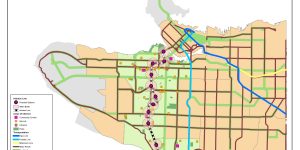
Within this project, our group set out to determine the feasibility of creating a fast-transit system on the Arbutus Corridor. This was a plan set out in 2016 for the city to incorporate a light rail into the corridor, and in our project we wanted to consider the potential locations in which a station could be placed in its most optimal point.
Lab 4- Rental Affordability Comparison of Vancouver to Montreal
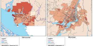
In this lab, we took to use 2016 census data to access rental housing costs and affordability in Metro Vancouver and compared to Montreal. We visualized quantitative data of Census Tracts (CT) and Dissemination Areas (DA), to compare the regions.
Lab 5- Environmental Impact Assessment of The Garibaldi
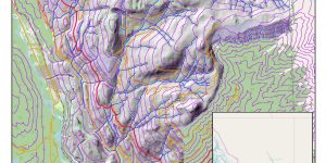
In this lab, we were given the role to analyse the environmental impacts of a proposed zone within Garibaldi Mountain. By creating a zone above 600m vertical, and using environmental data layers (OGMA, UWR, Rivers). We created visuals of the environmental areas that must be protected within the project's borders.
Lab 3- Planning For Potential Flooding and Storm Surges in Vancouver
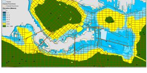
In this lab, we were given a scenario in which we took on the role of a GIS analyst in Metro Vancouver and looked at areas susceptible to flooding. We presented this potential scenario through ArcGIS, by creating multiple visual maps to show areas of Metro Vancouver which are up to 8m above sea levels.
Music and the City
My final paper written about the incorporation of music, specifically rap by artist Nas and his album 'illmatic', and how it defined the creation of the city of New York.
Policy Brief
A Policy Brief Created in 2018 to look at the illegal and dangerous methods of migration UAC (Unidentified Alien Children) took to seek refuge in Canada, and the deprived living conditions forced upon these children seeking asylum.